


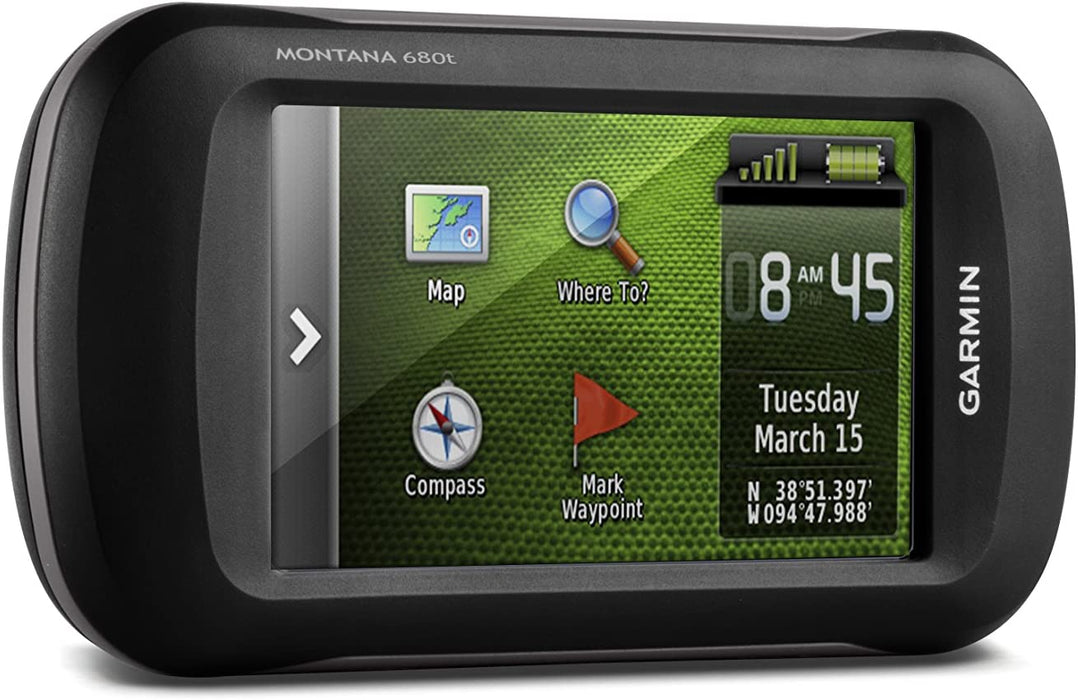
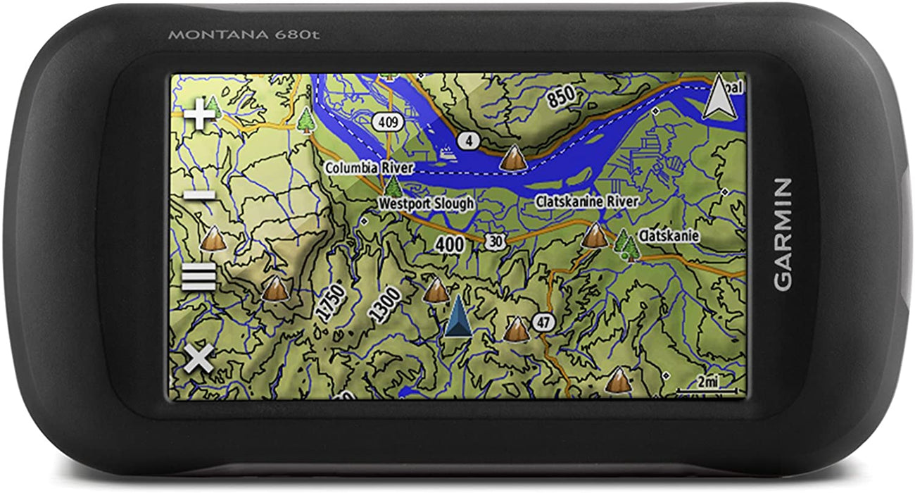
Garmin Montana 680t, Touchscreen Hiking Handheld, GPS/GLONASS and Preloaded TOPO Maps
This product ships from the United States
- PRELOADED GEOCACHES - 250,000 preloaded worldwide geocaches from Geocaching.com
- SEE YOUR SURROUNDINGS - Includes a 1-year Birdseye Satellite Imagery subscription1
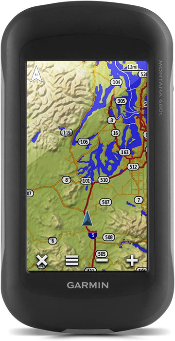
- GPS AND GLONASS - With its high-sensitivity, WAAS-enabled GPS receiver, Hotfix satellite prediction and GLONASS support, Montana locates your position quickly and precisely and maintains its location even in heavy cover and deep canyons
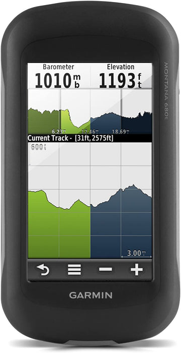
- TRACK MANAGER - Ability to organize and navigate through waypoints/routes/track logs (easily start/stop recording track logs)
- CAPTURE THE MOMENT - 8 megapixel digital camera for higher quality images and better resolution; geotagged with coordinates automatically, allowing you to


Take It Hiking. Take It Hunting. Take It On The Water.
Montana 680t features a dual-orientation, color touchscreen that’s glove friendly, comes preloaded with TOPO U.S. 100K maps and includes a 1-year BirdsEye Satellite Imagery subscription. The digital camera provides high-quality images, excellent resolution and automatically geotags photos with coordinates.
The handheld includes 3-axis tilt-compensated compass, barometric altimeter and access to both GPS and GLONASS satellites for improved positioning and typically faster fixes.
Montana 680t
Rugged GPS/GLONASS with 8 Megapixel Camera and Preloaded TOPO Maps.
- 4-inch dual-orientation, glove-friendly touchscreen display
- 8 megapixel autofocus camera; automatically geotags photos
- Tracks both GPS and GLONASS satellites
- Preloaded TOPO U.S. 100K maps; includes 1-year BirdsEye Satellite Imagery subscription
- 3-axis compass with barometric altimeter
|
|
|
---|---|---|
Find FunMontana supports paperless geocaching GPX files for straight-to-device uploading of geocaches from Geocaching.com. No more manually entering coordinates and paper print outs, Montana stores and displays key information, including location, terrain, difficulty, hints and descriptions. The track manager feature helps organize and navigate through waypoints/routes/ and track logs (easily start/stop recording tracklogs). |
Keep Your FixWith its high-sensitivity GPS and GLONASS reception, WAAS-enabled receiver and HotFix satellite prediction, Montana locates your position quickly and precisely and maintains it. Whether you’re in deep woods or just near tall buildings and trees, count on Montana to help you find your way when you need it most. |
Enjoy the ViewMontana has a vast 4-inch, sunlight-readable touchscreen display, giving you vivid colors and high-resolution images. Its easy-to-use touchscreen means you’ll spend more time enjoying the outdoors and less time searching for information. |

Plan Your Next Trip
Our free BaseCamp software lets you view and organize maps, waypoints, routes and tracks. This free trip-planning software even allows you to create Garmin Adventures that you can share with friends, family or fellow explorers. BaseCamp displays topographic map data in 2-D or 3-D on your computer screen, including contour lines and elevation profiles.
![]() |
![]() |
![]() |
![]() |
|
---|---|---|---|---|
Montana 680t | Montana 680 | Montana 610t Camo | Montana 610 | |
Display size, WxH | 2"W x 3.5"H (5.06 x 8.93 cm); 4" diag (10.2 cm) | 2"W x 3.5"H (5.06 x 8.93 cm); 4" diag (10.2 cm) | 2"W x 3.5"H (5.06 x 8.93 cm); 4" diag (10.2 cm) | 2"W x 3.5"H (5.06 x 8.93 cm); 4" diag (10.2 cm) |
Battery life | up to 16 hours (lithium-ion); up to 22 hours (AA batteries) | up to 16 hours (lithium-ion); up to 22 hours (AA batteries) | up to 16 hours (lithium-ion); up to 22 hours (AA batteries) | up to 16 hours (lithium-ion); up to 22 hours (AA batteries) |
Camera | yes (8 megapixel with autofocus; automatic geo-tagging) | yes (8 megapixel with autofocus; automatic geo-tagging) | ||
Preloaded maps | yes (topographic) | yes (topographic) | ||
Waypoints | 4000 | 4000 | 4000 | 4000 |
Track log | 10,000 points, 200 saved tracks | 10,000 points, 200 saved tracks | 10,000 points, 200 saved tracks | 10,000 points, 200 saved tracks |
Geocaching-friendly | ✓ | ✓ | ✓ | ✓ |
Custom maps compatible | ✓ | ✓ | ✓ | ✓ |
Area calculation | ✓ | ✓ | ✓ | ✓ |
Garmin Connect compatible | ✓ | ✓ | ✓ | ✓ |